The Society has a large collection of maps that cover the region's long and eventful history. There are more than 1,500 maps, most are encapsulated and available for use by the researching public. The maps that follow are most important for those doing research in the early periods of our region's history.
c. 1650 - c. 1783
The area known as "The Minisink" or "The Minisinks" is not a clearly defined area in any of the histories written about the region. However we have tried to give you a sense of where it was generally. This map shows the greatest extent of the description given to the Minisink region with current place names. It generally follows the Delaware River, from ridge top to ridge top on either side of the river. Other descriptions actually broaden that a bit. As one gets closer to the American Revolution the area shrinks in size and following the war the name went out of use because the area was divided up into towns and villages.
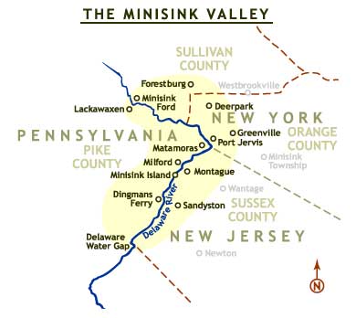
Our historical society, when originally formed, was created to save the history of the Minisink Valley which extended from Minisink Ford, New York to the Delaware Water Gap in New Jersey. Even today historians still are not in agreement as to the exact boundaries of the Minisink. This map is the first attempt to define the region using current data.

While there is some controversy surrounding the origins of this road, it is believed that this road (Route 209 in New York, Route 521 in New Jersey) was the first 100-mile road built in America. Some have suggested that it was built by Dutch explorers in the early 1600s. We have shown its location with the churches that were located along it in the 1700s. Also, place names that were in use at the time.

This map shows where the first settlements at Peenpack (present day Huguenot, New York) were. While this was created for a recent Cuddeback family reunion, there were a number of early settlers who had homes here including the Cuddebacks, Swartwouts, Van Inwegens, Provosts and Gumaers. Click Here to see a large version of this map in a new window.

This map shows where the Minisink Patent, a huge piece of land, which was granted in 1704, was located. The notation for the Delaware River delineates where Port Jervis is presently located. These were the major land patents in present-day Orange County.

The towns of Orange County were divided up after 1798. After that, the only geographic entity to bear the name of Minisink is the present day town that is east of Greenville which was named that after 1800.

This map, drawn by Clair Tholl is the best map for understanding how the legal boundaries evolved in the surrounding counties from the earliest settlement to their present lines.Click Here to see a larger version of this map in a new window.

Another problem in terms of the geography of our area was the fact that New Jersey once extended far into New York. The end point would have been at present-day Cochecton, New York. New York on the other hand would claim southward to at least present-day Milford, Pennsylvania and at one point, almost to Easton, Pennsylvania.
What all these maps demonstrate is that if you are doing research in our area, you may have to look in Perth Amboy, New Jersey (East Jersey Proprietor's Office) or Burlington, New Jersey (West Jersey Proprietor's Office) for records that include the Minisink area. Also, on the New York side you may have to look in Kingston for records because Ulster County extended farther south than it does now. All of this of course in addition to the relevant Orange County (NY) and Sussex County (NJ) organizations. We suggest that you go to the bibliography section of our web page for additional resources or take a look at our gift shop.
Former Executive Director
Minisink Valley Historical Society