Tri-State Points of Interest
The following information is availablce as a .pdf file for download and printing. Click Here to download (6.3 MB Adobe Acrobat PDF).
Port Jervis - Port Jervis was incorporated as a village May 11, 1853, carved out of the Town of Deerpark, and granted a charter March 30, 1866. On April 20, 1907 the village became the City of Port Jervis.
Port Jervis was named for the Chief Engineer of the Delaware and Hudson Canal Company. Port Jervis is not a port on the Delaware River; this section of the river is too shallow for anything but rafts, rowboats, canoes and kayaks. |

Erie Depot - Completed in February 1892 the current building replaced an earlier depot that burned to the ground on December 25, 1890. The two story brick building built in the Gothic Design with a gabled roof is artistically broken up in graceful lines and is surmounted with a graceful tower. A neat porte-cochere is at the entrance of what was the general wanting room. The rainy weather passengers could drive under the porte-cochere and walk directly into the depot. The building is ornamented with blue stone trimmings, terra cotta crestings on the edges of the roof, and terra cotta ornaments at the foot of the arch and tower windows. The wing of the building, on the west, is one story in height and was used for the baggage room and express office. The building was finished throughout with Georgia pine, trimmed with cherry, all the woodwork being cabinet finished, while a few pieces of hand-carved work ornaments the general waiting room. On the first floor was located the general waiting room, a smoking room, the ladies' waiting room, the ticket office, toilet rooms and closets. The ticket office was midway between the two waiting rooms. On the upper floor were the offices of the Dispatchers, the Delaware division Chief Dispatcher, the Delaware division clerks, Superintendant, Roadmaster and Trainmaster. The building was heated with steam and lighted with electric light. The steam heating and plumbing were the work of Swinton, Van Etten & Co. The contractors for the entire building were Grattan & Jennings of Buffalo, a
firm which had done a vast amount of work for the Erie. In 1980's the Port Jervis Erie Depot was saved from demolition by the community including the Port Jervis Development Corporation, the Community Development Corporation, the Depot Preservation Society and Minisink Valley Historical Society.
|
|
Cole's Fort - Present site of the Machackemach Village Senior Housing. On December 27, 1755, the provincial Council of New Jersey ordered forts to be erected on the New Jersey side of the river (Delaware) and appropriated 10,000 pounds to pay for the erecting and garrisoning of these forts. Cole's fort was located near the present intersection of Jersey Avenue and East Main Street. This fort was located on the homestead of Willem Cool (Cole).
|
|
Trolley -  The Port Jervis Electric Street Railway opened January 15, 1898. It went 3.3 miles from East Main, Ball, Fowler, Jersey, Front, Pike and West Main Streets to Riverside. The Port Jervis Electric Street Railway opened January 15, 1898. It went 3.3 miles from East Main, Ball, Fowler, Jersey, Front, Pike and West Main Streets to Riverside.  The powerhouse and a facility for housing and repairing the cars was located in Germantown or West End.
In 1901 the street railway was combined with other utilities to form the Port Jervis Electric Light Power Gas and RR Co. The cars and track were in poor condition and on June 9, 1910 the line closed down. The street railway was separated from the other utilities and reopened on July 24, 1910 as the Port Jervis Traction Company. The line was never very profitable and revenues declined, on November 18, 1924 the line was abandoned. The powerhouse and a facility for housing and repairing the cars was located in Germantown or West End.
In 1901 the street railway was combined with other utilities to form the Port Jervis Electric Light Power Gas and RR Co. The cars and track were in poor condition and on June 9, 1910 the line closed down. The street railway was separated from the other utilities and reopened on July 24, 1910 as the Port Jervis Traction Company. The line was never very profitable and revenues declined, on November 18, 1924 the line was abandoned.
|

Laurel Grove Cemetery - Designed by NYC architect Howard Daniels opened July 15, 1856. Cemeteries at the time were being designed not only as final resting places but as a recreational area as well. Dr. John Conkling was the founder and first president of the association. The winding paths are lined with hemlocks, pines and laurels. The beautiful monuments and mausoleums testify to the fact that this is the final resting place for many prominent citizens.
|
|
The Jersey Claim Line - When people of New Jersey came to take possession of their lands, they found that they had been occupied for some time by people with grants from New York. They would not yield their property so general border warfare continued for many years. The New Jersey Claim line was run in 1720. This line left the Hudson River on a course running 8 degrees north of the present line striking through Tuxedo Park and North of Warwick, NY and ended on the Delaware River at Cochecton. New York claimed the line should strike the Delaware at the Neversink river mouth. Raids and reprisals by property owners and by county officials became so serious that the Provincial Government was forced to act. The commission finally appointed in 1764 designated by the King of England and was comprised of officials, surveyors and lawyers. This commission finally fixed the controversial point at the mouth of the Neversink River.
|

Station Rock - The location of the Tri-States rock is at the  south west end of Laurel Grove Cemetery at the confluence of the Neversink and Delaware Rivers. Directly under where Route 84 passes over the end of the cemetery is a Witness Monument but if you climb down to the river you will see the Station Rock. At a point on the shore of the Delaware River is a large boulder covered with water when the river is high. This boulder is called Station Rock. south west end of Laurel Grove Cemetery at the confluence of the Neversink and Delaware Rivers. Directly under where Route 84 passes over the end of the cemetery is a Witness Monument but if you climb down to the river you will see the Station Rock. At a point on the shore of the Delaware River is a large boulder covered with water when the river is high. This boulder is called Station Rock.
|
|
Neversink Bridge - The first bridge  built in this location in 1820's was a wooden covered structure, replaced in 1868 with a wood and iron suspension bridge. Ice demolished this one in 1904 and a 3rd bridge was erected and served until 1929 when it was replaced with an iron bridge. built in this location in 1820's was a wooden covered structure, replaced in 1868 with a wood and iron suspension bridge. Ice demolished this one in 1904 and a 3rd bridge was erected and served until 1929 when it was replaced with an iron bridge.
|
Montague, Sussex County, New Jersey - The Montague Precinct was created in 1759. High Point State Park covers a large portion of the eastern side of the township. . The land for High Point State Park was donated by Colonel Arthur and Susan Kuyser. On the highest point in New Jersey the High Point Monument was erected in 1930 "Glory and Honor and Eternal Memory of New Jersey's Heroes by land, sea, and air in all wars of our country."
|
|
Tri-State Bible Camp - When Conrad Schneider died in 1880,  he was the proprietor of the Schneider House restaurant, a saloon and meat market located in Port Jervis. He also owned a fine farm near Carpenter's Point. When a large inn was erected (1906) for housing visitors it was known as Schneider's Inn. The property has also been known as Pine Cliff Farm, Pine Cliff Lodge & Pine Grove. It was usually listed with a Port Jervis address because Montague did not have a Post Office. Elmo Bateman purchased the 85 acre property to use as a Bible Conference Center. With its beginning in 1949, Tri-State Bible Camp exists to be an aide to the local church as a camping ministry. Tri-State Bible Camp is owned and operated by the Fellowship of Fundamental Bible Churches. . he was the proprietor of the Schneider House restaurant, a saloon and meat market located in Port Jervis. He also owned a fine farm near Carpenter's Point. When a large inn was erected (1906) for housing visitors it was known as Schneider's Inn. The property has also been known as Pine Cliff Farm, Pine Cliff Lodge & Pine Grove. It was usually listed with a Port Jervis address because Montague did not have a Post Office. Elmo Bateman purchased the 85 acre property to use as a Bible Conference Center. With its beginning in 1949, Tri-State Bible Camp exists to be an aide to the local church as a camping ministry. Tri-State Bible Camp is owned and operated by the Fellowship of Fundamental Bible Churches. .
|

Indian Raid - Joseph Brant with Mohawk allies and British Loyalists raided the area on July 20, 1779. This marker is located on South Maple Avenue in Deerpark on the left side of the road near Silver Canoe.
|

South of the Border Tavern - 1 River Road, Montague, Sussex County, NJ & 87 South Maple Avenue, Deerpark, Orange County, NY - This building was built on the State line dividing New York and New Jersey. At one time there was a dividing line painted on the floor. New York state drinking age was 18 and New Jersey was 21, needless to say it was a popular spot.
|

Banach Brothers - Twins Lou and Ed Banach are  the only athletes to enter the Olympics from Port Jervis. In 1984 they were named to the U.S. Olympic wrestling team during their wrestling years at Iowa State University. The Olympics were held in Los Angeles, CA. On August 9th Ed won gold in his weight class and on August 11th Lou won his gold medal. the only athletes to enter the Olympics from Port Jervis. In 1984 they were named to the U.S. Olympic wrestling team during their wrestling years at Iowa State University. The Olympics were held in Los Angeles, CA. On August 9th Ed won gold in his weight class and on August 11th Lou won his gold medal.
|
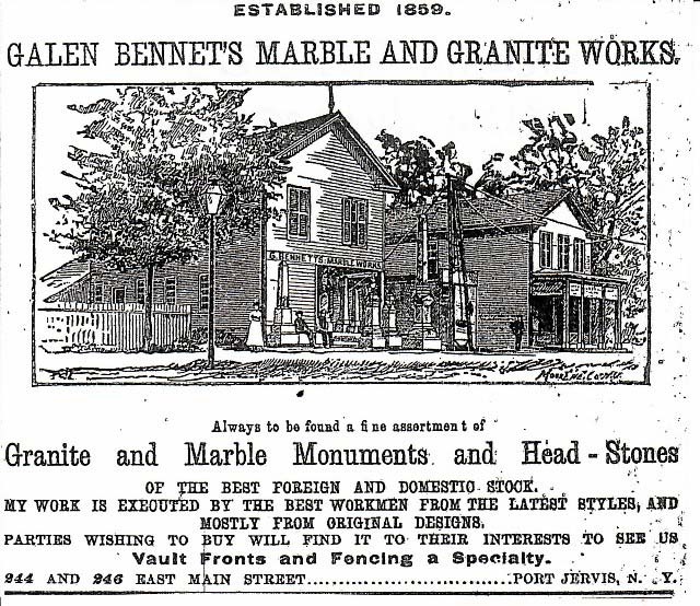
Galen Bennet - The two small buildings, 244 & 246 East Main Street, on your right next to the Neversink Bridge belonged to Galen Bennet; his home was further up the street at 234 East Main Street. His home and the two buildings are shown on an 1875 Atlas of Orange County, NY. Galen was a stone carver and both of these building were used in his business. Many of the tombstones in Laurel Grove cemetery were the work of Galen Bennet. He was married to Elizabeth Conkling daughter of the Dr. John Conkling founder of Laurel Grove Cemetery.
|
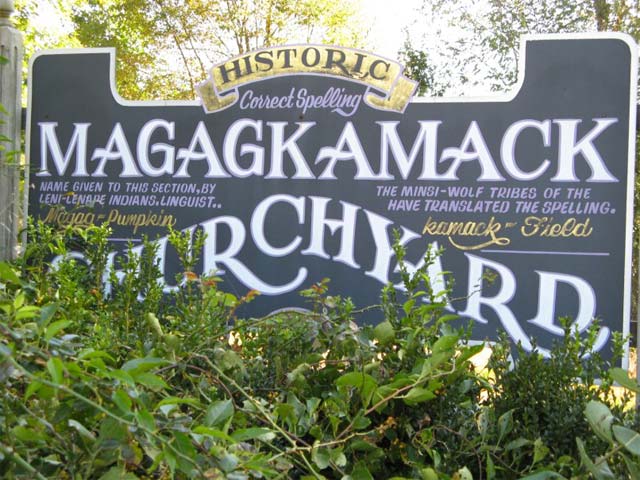
Magagkamack Cemetery - site of the first Dutch Reformed Church building, which was burned when Joseph Brant and his troop raided the valley in July 1779. This is the final resting place for Revolutionary War Soldiers Martinus Decker and Jacob Squirrel.
|
|
Old Mine Road -  Tradition says that the Dutch built the first 100 mile road in America prior to 1664. The road is report to go from Kingston to copper mines in Pahaquarry, New Jersey. Critics believe the road was just a series of Indian trails that widened through increased use. However the road was in existence after 1700. Today New Jersey route 521 and New York Route 209 approximately follow the old road. This historic marker located on East Main Street in front of the Middle School. Tradition says that the Dutch built the first 100 mile road in America prior to 1664. The road is report to go from Kingston to copper mines in Pahaquarry, New Jersey. Critics believe the road was just a series of Indian trails that widened through increased use. However the road was in existence after 1700. Today New Jersey route 521 and New York Route 209 approximately follow the old road. This historic marker located on East Main Street in front of the Middle School.
|
|
Deerpark Reformed Church - was organized in 1737 and is the oldest congregation 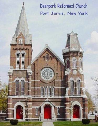 in the area. The original church was located in the back of the Machackemech cemetery The present building was constructed between 1868 and 1870. in the area. The original church was located in the back of the Machackemech cemetery The present building was constructed between 1868 and 1870.
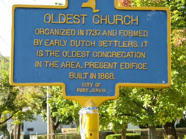 Historic marker located on East Main Street near the corner of Sullivan Avenue. |

Home of Judge William Crane - located at 19 East Main Street. He was secretary of the Board of Education, Treasurer of the Port Jervis Water Works, and Special Judge for Orange County. William Crane was the older brother of Stephen Crane. Stephen is said to have frequently visited the area and stayed at his brother's home. He wrote several of his books including the Red Badge of Courage. The house is now the offices of Bavoso, Plotsky, and Onofry. This Marker is located at 19 East Main Street.
|

Orange Square - During the Civil War 428 names were listed on the Port Jervis honor roll of these 45 were killed. Twenty years after the war Mrs. Diana Farnum the widow of Henry H. Farnum provided funds for the erection of a Civil War monument. The only stipulation was that the monument be located in Orange Square.
This property was given to the village by the Delaware and Hudson Canal Company for use as a park. The monument was dedicated on July 5, 1886.  Located between Sussex & Pike Street, and North and South Broome Street. |

Drew Methodist - Sussex Street - In 1838 the church organized as "The First Methodist Episcopal Church in Port Jervis." In 1866 outgrowing their original church a new one was erected on the corner of Sussex and East Broome streets. Stephen Crane's father was briefly a minister at this church.
|

1st Presbyterian Church - organized on July 15, 1851. This is the oldest church building in Port Jervis, dedicated on December 24, 1852 it was built at a cost of $5,000. Henry H. Farnum donated the land on the corner of Sussex and Brome streets on which the church stands.
|
|
Canal Hotel & Canal Crossing - D&H opened 1825 and on November 5, 1898 the  last boat departed from Honesdale, PA. The Canal Hotel was located on the corner of Canal Street & West Main Street. last boat departed from Honesdale, PA. The Canal Hotel was located on the corner of Canal Street & West Main Street.
 This historic marker is located at West Main Street between Canal and Hudson Streets.  Marker on West Main Street between Canal and Delaware Streets. |

D&H Canal Trail - At the intersection of Grandview Avenue and West main Street you will find a paved walking trail.  Marker located across the street from the entrance to the trail. |

Fort Decker - built by Frederick Hayne prior to 1760 used as a trading post, tavern, and home. Never an official fort it was a safe haven for  residents of the surrounding area. The fort was burnt during a raid by Joseph Brant on July 20, 1779 which led to the only major battle of the area at Minisink Ford. Martinus Decker either rebuilt or remodeled the building in 1793. In 1819 the building and grounds were purchased by Benjamin Dodge and Stephen St John for $5,000. St John and his wife lived in the stone house and in 1826 they sold a right of way across the property to the D & H Canal Company. Stephen St John turned his home into the St. John Canal Hotel during the building of the canal. In 1846 St John subdivided the remaining farm land and sold 60 acres to the Erie Railroad. In 1865 the remaining lots and stone house were purchased by John Cannon. In 1970 the Minisink Valley Historical Society purchased the stone building from the estate of Nellie Cannon for $1,000. residents of the surrounding area. The fort was burnt during a raid by Joseph Brant on July 20, 1779 which led to the only major battle of the area at Minisink Ford. Martinus Decker either rebuilt or remodeled the building in 1793. In 1819 the building and grounds were purchased by Benjamin Dodge and Stephen St John for $5,000. St John and his wife lived in the stone house and in 1826 they sold a right of way across the property to the D & H Canal Company. Stephen St John turned his home into the St. John Canal Hotel during the building of the canal. In 1846 St John subdivided the remaining farm land and sold 60 acres to the Erie Railroad. In 1865 the remaining lots and stone house were purchased by John Cannon. In 1970 the Minisink Valley Historical Society purchased the stone building from the estate of Nellie Cannon for $1,000.
|

Gillinder Glass - Founded by William T. Gillinder in 1861 and established in Port Jervis in 1911. The company produces about half of the airport runway lights used in the US. They produce a wide range of glass from hand blown bowls to industrial glass.
Special tours of the plant are offered, and they have a well stocked gift shop, which is open 7 days a week.
|

Rafting on the Delaware - Timber rafts were floated down the river on the spring freshet to Trenton, New Jersey and then to markets in Philadelphia, Pennsylvania.
|
|
Ferry Street - The site of early ferry service which went back into operation when the bridges went out. It was also to be the location of a railroad bridge into Matamoras which never materialized. There was a bridge built in 1854, a wooden bridge made to carry foot, vehicle and railroad traffic. It lasted until March 1870 when it blew into the river in a wind storm. You can still see the stone pier in the middle of the river when you walk along the heritage trail on top of the dike on River Road.
|

Dikes - After a series of floods devastated the area, a $35,000 appropriation was approved to build a line of dikes. In 1904, supervised by state engineers the dikes were built to protect the lowlands that bordered the rivers.
|
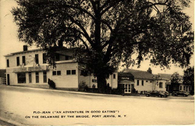
Flo Jean's Restaurant - A small portion of this building served as the toll house for the first suspension bridge built here. Part of the Flo-Jean's property was known as Kirk's Grove where they held picnics and concerts. The restaurant got it's name from sisters Florence and Jean Hoey who stared a tea room, only serving sandwiches and tea. Florence and her husband Harold Dalrymple expanded the tea room into a restaurant. Some of the well known visitors to Flo-Jeans were Babe Ruth, Jimmy Cagney and Bing Crosby.
|
|
Delaware Bridge - The first Barret bridge at this location opened June 24, 1872. It was a suspension bridge built at the cost of $40,000.00. It was privately owned and was maintained by tolls. This bridge was taken out when an ice gorge on March 17, 1875 carried the railroad bridge from Mill Rift down river and ripped away the lower towers and cables of the Pike Street Bridge. Almost immediately the owners replaced the structure using parts of the first bridge opening just 81 days later on June 9, 1875. This bridge remained in operation until the flood of October 10, 1903. Once again faced with constructing a new bridge they decided to build an iron two span structure which was completed and opened August 2, 1904. The bridge was reinforced in 1919 and lasted until 1939. New York and Pennsylvania combined to take over the bridge ownership in 1922 doing away with the tolls. This bridge was replaced in 1939 and named the Mid-Delaware Bridge.
|
|
Eel Weir - If you look to your right as you cross over the bridge into Matamoras you will see the remains of an old eel weir near the bank of the river. Delaware River eels are a sought after delicacy particularly in New York City.
|
Matamoras, Pike County, PA - Matamoras was once a village in Westfall Township, it became a Borough in Pike County on January 18, 1905. In 1846 Matamoras was named after Matamoros, Mexico which is located across the Rio Grande from Brownsville, Texas.
|

Chrissie's Place - Originally owned by the Schroeder family the building once housed the Matamoras Post Office. It was called "The Mayor's Corner" for many years.
|

Westfall Fort - believed to be the oldest house in Matamoras, it was built in the 18th century by Simeon Westfall. Located on First Street, this building is privately owned and has an historic marker in front that mistakenly identifies it as Fort Matamoras.
|
|
Airport Park - which lies in the easterly side of Matamoras along the Delaware River, was carved out of an abandoned airport.
 The airport was originally built by the firemen of Matamoras in memory of Mazel M. Merrill and Edwin Ronne, the aviators who crashed in the woods outside Milford, PA on August 27, 1928. The firemen turned the airport over to the Borough of Matamoras during the Depression so WPA funds and workers could be used to finish the project. During World War II fighter pilots were trained at the facility, after which it was leased by a private citizen, Zeki Dervend. The construction of Interstate Route 84 caused the airport to be closed, and in 1972 the Matamoras Recreation Advisory Board began to build a recreational park with ball fields, pavilions, a football field, a tot lot, and tennis courts.
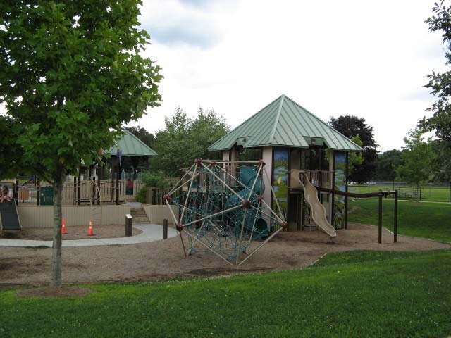
In 2009 Firefly Field replaced the original tot lot with a handicap accessible area for children twelve and under. Firefly Field has swings, slides, a sandy area, a pavilion, etc; it is a marvelously unique play area. The airport was originally built by the firemen of Matamoras in memory of Mazel M. Merrill and Edwin Ronne, the aviators who crashed in the woods outside Milford, PA on August 27, 1928. The firemen turned the airport over to the Borough of Matamoras during the Depression so WPA funds and workers could be used to finish the project. During World War II fighter pilots were trained at the facility, after which it was leased by a private citizen, Zeki Dervend. The construction of Interstate Route 84 caused the airport to be closed, and in 1972 the Matamoras Recreation Advisory Board began to build a recreational park with ball fields, pavilions, a football field, a tot lot, and tennis courts.
In 2009 Firefly Field replaced the original tot lot with a handicap accessible area for children twelve and under. Firefly Field has swings, slides, a sandy area, a pavilion, etc; it is a marvelously unique play area. |
 Veterans Memorial Park and Education Center - is an area in the northern part of Airport Park set aside for monuments depicting all wars
 in which our country was involved; the main focus of Vets Park is to educate citizens about each war using text and maps.
Finished monuments in the park include: World War II, Korea, Vietnam, the Cold War, and 9/11; work is advancing on the Civil War monument. in which our country was involved; the main focus of Vets Park is to educate citizens about each war using text and maps.
Finished monuments in the park include: World War II, Korea, Vietnam, the Cold War, and 9/11; work is advancing on the Civil War monument. |
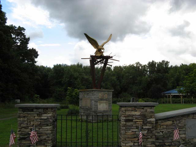 Veterans Park is a work in progress. Veterans Park is a work in progress. |

Riverside Park - owned by the City of Port Jervis it was once owned by the Erie Railroad. The Erie used this area for it's stockyard  with a series of pens used to contain cattle livestock on its way to market. Today the city uses it as a recreational area. with a series of pens used to contain cattle livestock on its way to market. Today the city uses it as a recreational area.
|
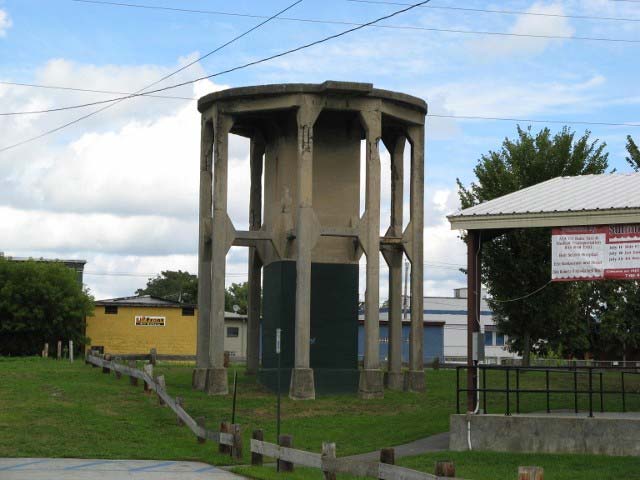 This concrete structure is the base of an Erie Railroad water tower. This concrete structure is the base of an Erie Railroad water tower. |

Pike Street Underpass -
replaced the 1848 railroad crossing in 1936 - which caused my traffic backup and accident. Horse vs train and auto vs train. Necessitated the removal of two blocks of stores and business places on Pike Street on both sides of the street.
|

Park Avenue Observatory - During the depression in the 1930's President Franklin D. Roosevelt set up programs to provide work for the huge group of unemployed.
In 1933 & 1934, through the WPA project Port Jervis received a new scenic approach - Park Avenue and the observatory.
|
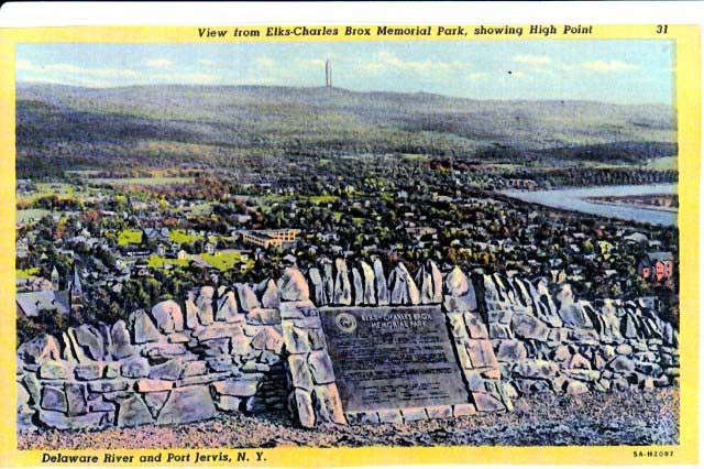
Elks Brox Park -
purchased in 1914 with a donation by the Elks Club and another donation by the estate of Charles Brox. Skyline Drive leading up to the park was dedicated in 1921. It was a dangerous road in the early years because there was no guardrail on the steep curving road.
|