The following is a text-only version of the city's Delaware River Heritage Trail Guide. The beautifully illustrated trail guide is forty pages long and includes photographs and a map. It is available for $6.95, postage included, from the Minisink Valley Historical Society. The Society can be reached at PO Box 659, Port Jervis, New York 12771.
"The City of Port Jervis is proud to have worked with the Minisink Valley Historical Society in creating this trail for both our citizens and visitors alike. Whether one wants to take a leisurely walk along the river, see our one of city's many historic sites or just have lunch at one of the park benches, it is a great asset."
"The Delaware River Heritage Trail and greater Port Jervis region offer stunning views, are easy to access, and offer a wonderful opportunity for individuals and families to spend time in the Upper Delaware region. Walk in the day, see a show at any of our region's arts venues at night, and find a great hotel or B&B where you can stay. The Upper Delaware Region is spectacular!"
^nbsp;
Welcome to Port Jervis and the Delaware River Heritage Trail. The trail, owned and operated by the city, was created to allow walkers, hikers, tourists and residents to enjoy the city's historic sites and river vistas that have been immortalized in photographs, songs, paintings and literature. It is approximately six miles long.
The trail begins at Fort Decker at 127 West Main Street. Standing on the porch with your back to the building, turn right and proceed to Ferry Street where you will make a left, then along River Road to Water Street. From Water Street the trail continues on to Pike Street where it turns left and then right onto King Street at the traffic light. Follow King Street into Riverside Park. At Riverside Park the trail goes to the ballfield, up to the dike, and loops back out of the park. Be sure to go up onto the dike, and see the wonderful view of the bend in the river, and New Jersey's High Point monument in the distance.
The trail then follows King Street back out to Pike Street, makes a right turn, goes through the underpass, and loops back around to the right then makes a left onto Front Street which becomes Jersey Avenue. Follow Jersey Avenue to East Main Street. At East Main Street, make a right turn; follow East Main to South Street and then make a right turn and proceed to the western entrance of the Laurel Grove Cemetery and Delaware Drive.
There it follows Delaware Drive to Tri-States Rock at the junction of the Delaware and Neversink Rivers, where the states of New York, New Jersey and Pennsylvania meet.
The trail then exits the cemetery along Neversink Road and the Neversink River onto East Main Street. Bear left and follow East Main Street until Sussex Street where you will make a left. Then turn right at Broome Street, passing through Orange Square and continuing across Pike Street. Follow Broome Street to Canal Street. At Canal Street turn right for one block then left onto West Main Street. Follow West Main Street back to Fort Decker.
The trail is signed in both directions, except in Laurel Grove Cemetery because of safety concerns. Arrows under the sign indicate directional changes when needed. Please help us keep the trail clean; watch for traffic when traveling on city streets, and enjoy your time in Port Jervis.

Three sections of the trail are completely ADA-compliant. The section between Ferry Street and Water Street, the short section in Riverside Park, and the route within the Laurel Grove Cemetery are all blacktopped, level and wide enough for a wheelchair.
The rest of the trail is located on sidewalks, packed dirt paths and roadways with all of the various challenges that one might encounter - uneven sidewalks, no curb cuts and steep inclines. There are ADA-compliant parking spaces at the entrance to the West End Beach, Lumber Street and River Road and at the western entrance to Laurel Grove Cemetery. There is a handicapped-accessible bathroom at the West End Beach Park which is open when the park is open.
The city is continuing a long-term program of creating accessible curb cuts and repairing its sidewalks. People using wheelchairs have traveled the entire length of the trail; while parts were difficult to negotiate, with the help of companions they were able to travel across the entire trail. We have tried to make it as accessible as is readily achievable, given funding and practical considerations.
127 West Main Street, Port Jervis, New York
The stone house at the trailhead was built in 1760, and burned by Joseph Brant and his Indian raiders during a Revolutionary War raid in 1779. It is the museum of the Minisink Valley Historical Society and is open to the public regularly. The house was rebuilt in 1793 by Martinus Decker, and served as a hotel and tavern during the years when the Delaware and Hudson Canal was being built. John B. Jervis, one of the canal's chief engineers and the man for whom Port Jervis is named, stayed here in the 1820s. After that the house served as a private residence until 1958. The Society bought it in 1970, developing it into a museum and center for its ongoing activities. It is now listed on the National Register of Historic Places and on the New York State Revolutionary War Trail.
River Road, Port Jervis, New York
From the trail along River Road you can see a stone pier in the center of the river, the remnant of a railroad bridge built in the late 19th century in an effort to connect the Pennsylvania towns of Milford and Matamoras with Port Jervis and the Erie main line. The bridge was ultimately destroyed by the force of the river in the early years of the 20th century. A little further along River Road, on the left behind the large industrial building (which manufactures parts for the aerospace industry among other things), is a large flat area where the Erie Railroad's Delaware Division shops and headquarters were once located. Some twenty-five hundred men worked in these repair and car shops; in 1900 the payroll for these men was $100,000 per month. The Port Jervis and Monticello Railroad, and its successor, the Ontario and Western, also used the Port Jervis facilities for maintenance of their cars.
Water Street, Port Jervis, New York
The Pike Street portion of this building once served as the toll house for a suspension bridge that spanned the Delaware River here at this spot. The bridge opened in 1872 but was destroyed by an ice gorge several years later. There were several other bridges at this location after that; the current bridge was built in 1939. Portions of the Flo-Jean's property were once known as Kirk's Grove, a recreational picnic area, and a popular spot for band concerts and orchestras. The restaurant itself is well-known and has had many noted visitors, including Thomas E. Dewey and Hugh Carey, New York State Governors, and Babe Ruth, Bing Crosby and James Cagney.
At the Flo-Jean, the remains of an old eel weir are visible near the northern bank of the river. Eels are captured when coming downstream on their way to the Sargasso Sea to spawn in the late summer. The eels follow the wings of the weir until they are trapped at the lower end of the "V" where they are caught and sold. Delaware River eels are a much sought-after delicacy, particularly in New York City.
City of Port Jervis
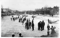
The Riverside Park is a city-owned park along the river, one of the few municipally-owned parks along the Upper Delaware. The city has developed sports facilities and boating and fishing access areas on this property. The area was once used by the Erie Railroad and on the left, near the railroad tracks, were a series of pens used to contain cattle on their way to market, earning this area the nickname "The Stockyards." Further into the park, the area is covered with cinders, which is waste ash leftover from steam engines that operated here until the late 1940s. Beyond the ballfield there are several short paths that lead directly to the river, but they are not on the Delaware River Heritage Trail.
15 Jersey Avenue, Port Jervis, New York
To the left of the entrance to the park, across the tracks, is the Port Jervis Erie Depot, a large red brick building with a gray roof. The depot was built in 1892, enlarged in 1912, and used for passenger service until 1974. It served as the headquarters for the Delaware Division of the Erie Railroad which stretched for approximately 105 miles from Port Jervis to Susquehanna, Pennsylvania. At one time the depot was the nerve center of Port Jervis until railroad operations fell into decline and the building was closed and boarded up. It was restored through the efforts of the Minisink Valley Historical Society, the Depot Preservation Society, and the Port Jervis Development Corporation. It is now owned by two developers. A museum operated there from 1989-2002.
Matamoras, Pennsylvania
As you look out on the river from the dike you will see a ledge in the river known as "Sim's Clip," named for Simon Westfall whose circa 1740 stone house is located across the river in Matamoras, Pennsylvania, just southwest of the ledge. Surveyors, representing the Royal Commission of 1769, stayed in this house while they agreed upon the termination point of the forty-eight mile long boundary line between the colonies of New York and New Jersey. The house is typical of stone houses built by early Dutch and French Huguenot settlers; it is now known as Fort Matamoras, although Matamoras did not get its name until the middle of the 19th century.
Along the Upper Delaware, bald eagles winter from November to March. Their brilliant white heads and tail feathers indicate they are mature eagles, probably four or five years old. During the summer, you may see ospreys diving for fish. There are several species of birds including ducks, herons and geese; also deer, black bear, muskrats and beaver that make the region their home. During the spring, shad swim upriver to spawn; trout, bass, and walleye also call the river home. Snakes also live in the area, and while most are nonpoisonous, there are rattlesnakes and copperheads, which are probably more afraid of you than you are of them.
Wildflowers abound in the Delaware River Valley: day lilies, wild columbine, sweet peas, daisies, foxglove, Joe-Pye weed, jewel weed and primroses, to name a few. Perhaps one of the most beautiful times along the river is in late August when loosestrife is in bloom. This purple weed, not native to North America, but rather an invasive species that was transplanted here, is waging a battle with native goldenrod for possession of the marshes and river's banks.
While traveling through the Riverside Park the trail parallels the railroad bed, which is still used by freight and passenger trains. This is the former main line of the renowned New York and Lake Erie Railroad. With the introduction of diesel engines in the late 1940s, increased use of trucks for shipping, and the construction of the interstate highway system, many railroads and the towns across America that served them, went into decline. Port Jervis was one of them.
When the major railroads in the Northeast went bankrupt in the 1970s, the Consolidated Rail Corporation, known as Conrail, was formed. With the breakup of Conrail, the Norfolk-Southern Corporation assumed control of the trackage. Passenger service is still maintained by the Metro-North Commuter Railroad and New Jersey Transit. The end of their commuter line is in Port Jervis, just beyond the Pike Street underpass.
East Main Street, Port Jervis, New York
The trail continues to the western entrance of Laurel Grove Cemetery at Delaware Drive. This cemetery may have been the first in Orange County to be designed by a landscape architect, a trend that became popular in the 1850s. It was designed by B. F. Hathaway; the roads and plantings still reflect his artistic design.
Some fifteen thousand people are buried here; there are an extraordinary and diverse number of monuments, tombstones and mausoleums representing the "golden age" of mortuary art in the late 19th century. The cemetery is undergoing efforts to restore the grounds to their former beauty; please treat this place reverently and do not litter. Also, as you walk along the cemetery's roads be mindful of the car traffic that may be passing through.
The Carpenter family is buried in a plot at the southern end of Laurel Grove Cemetery where their monuments are still visible. They once operated a ferry here, at Carpenter's Point, between New Jersey and Pennsylvania.
Juncture of New York, New Jersey and Pennsylvania
One of the city's most famous landmarks is the Tri-States Monument where a person can stand on three states at one time. The rock is located just beyond the Interstate Route 84 bridge. This is the site where a 100-year boundary dispute between the colonies of East and West Jersey and New York was finally resolved in 1769. At this location, renowned Philadelphia astronomer David Rittenhouse took the measurements that were the basis for the western termination point of the land boundary between the two colonies.
In the 1880s, it was discovered that many of the monuments from the 1774 marking of the boundary had disappeared, and a new effort was made to mark the line. The witness monument located here is one of the official boundary markers now recognized by both states, the United States Congress and the Federal Government. It also marks the terminus of the New Jersey and New York boundary line.
The Delaware River winds its way past the monument to Delaware Bay, some 255 miles to the south. The Delaware Water Gap National Recreation Area begins eight miles south of here, and the Upper Delaware Scenic and Recreational River begins six miles to the north. Both areas are managed by the National Park Service. The Neversink River, a world-class trout stream, merges with the Delaware at this point. It originates in the Catskill Mountains, many miles away.
As you exit the cemetery you will be following East Main Street. One of the most enduring legacies of the Victorian Age in Port Jervis is its interesting collection of architecture. Former building assessor Nelson Hammond has estimated seventy-five percent of the city's current inventory of buildings date from the last twenty-five years of the 19th century and the early years of the 20th century. There is an amazing array of architectural styles demonstrating that the bustling village did its utmost to keep up with the times, and the early years of the last century were especially good ones for residential and commercial construction.
One contemporary brochure noted that "architectural excellence of the city's public buildings compared favorably with larger cities." Another brochure describing the area states, "There were scores of beautiful private homes where good taste in architecture has been combined with pleasing landscape effects." There are numerous examples of what have become collectively called Victorian styles which include Gothic Revival, Italianate, Stick, Second Empire, Queen Anne, Shingle, Folk Victorian and Colonial Revival styles. It is interesting to note that many of the larger homes in the city were designed by architects from New York City since Port Jervis was only a short train trip away. The Classical Revival, Craftsman and Tudor styles were popular during the early years of the 20th century.
One of the most popular styles was Gothic Revival, used by Newburgh, New York designer Andrew Jackson Downing. The style was very popular throughout Orange County and offered residents a distinctive alternative to earlier classical styles. The Gothic style was known for its sharply pitched gables decorated with verge boards and finials. Another popular residential and business building style was Italianate, featuring bracketing along the cornice, large bay windows, double doors and, in the case of the Samuel Farnum House on Ulster Place, a tower. The Second Empire design was another popular residential and commercial style.
As one passes along East Main Street and the various side streets there is a vast array of buildings that represent the high styles of the period. Not only wealthy people constructed these fine homes but many were built by middle-class residents. Some retain impressive porch supports, gingerbread, bracketing, roof crestings, corner brackets, wrap-around porches, shutters and beautiful interior moldings with large sitting rooms and fireplaces.
Most of the churches in Port Jervis were built during this period and reflect the design of architects better known in New York City circles. The Gothic Revival style was especially popular. The community was deeply devoted to its religious heritage, and the architecture reflects the commitment of various faiths to having the finest of facilities. The growth of church membership was amazing during the Victorian Era; in 1893 there were seven churches, and by 1912 there were thirteen.
Many of the commercial buildings which line Front and Pike Streets and Jersey Avenue were built during this time. The latest designs used pre-molded sheet steel cornices, elaborate cast iron entrance ways, and beautifully carved window moldings. The finest buildings constructed in the city include the Elks Building (1908), Port Jervis Free Library (1903), the United States Post Office (1914), the Masonic Building (1882), the YMCA building (1912), and many of the community's earliest banks. The Hotel Minisink (1924), and the Rutan Building (1927), located downtown, were representative of the commercial boom that occurred during the 1920s.
Many of the period's significant residential buildings have been covered over or altered in ways that hide their former beauty. Homes and commercial buildings constructed during the last years of the 19th century and early years of the 20th century were often embellished extravagantly. As late as the 1940s, most of the city's buildings retained their gingerbread and decorative ornaments. However, in what has always been a uniquely American tradition of progress, many buildings were covered with asbestos and asphalt siding in the 1940s and 1950s to make them look more "modern." In fact, if one looks through the Port Jervis Urban Renewal photograph files, much of the city's most impressive architecture was still standing until the 1960s.
It was during this time a Federal government policy used by local municipalities helped to destroy many of America's downtowns in the hope of creating new, vibrant, modern business districts. In this city, more than fifty buildings were torn down in the 1970s; many of them were the most beautiful and impressive of the Victorian Age.
In fairness to local and national leaders of the time, the promise of Urban Renewal for many towns like Port Jervis was intriguing. They tried to revitalize a town that had endured the economic calamity during the decline of the railroad. Officials saw great benefit in having "substandard and blighting influences" removed and modern buildings constructed in their place to increase the city's tax base. The collapse of a large building on Pike Street in 1971 caused concern regarding the safety of older buildings.
The program promised to improve water and sanitary sewer systems, public buildings and the environment. Indeed, projects like a new city hall and fire house complex, and improvements to the business district, were completed. The main promise of Urban Renewal, the renewal of the downtown, however, was never achieved. Cities like Port Jervis now have places where newer buildings are not compatible with the rest of the town, causing a crazy quilt effect, destroying much of what had been historically significant.
Port Jervis was not alone in Orange County in undertaking Urban Renewal programs. The city of Newburgh was also involved in the program, demolishing much of its East Side during this period. As a result of the public clamor that arose across the nation, historic preservation organizations and preservation-minded individuals began to get involved with saving the architectural legacy of their communities, and the Urban Renewal program fell out of favor.
As you pass along East Main Street you are traveling along what many believe is the Old Mine Road, the first 100-mile road in American history. Some have said it was constructed by Dutch explorers to get copper from mines near Pahaquarry, New Jersey to Kingston, New York or Esopus as it was then known, and back to Holland. In New York State, the road essentially follows State Route 209; in New Jersey, it follows County Route 517. Other historians believe the road was originally a series of Indian trails that were enhanced by continual use, and that other kinds of mines were located on the Shawangunk Ridge as well as those said to be at Pahaquarry; hence the name of the road. As you walk along East Main Street, you will pass the Machackemeck Churchyard, the final resting place of about three hundred people. A number of Revolutionary War patriots are buried here. The churchyard was restored by the Deerpark Reformed Church, the City of Port Jervis and the Minisink Valley Historical Society. Further along you will pass through the original center of town which was located at the junction of Kingston Avenue and East Main Street.
Broome Street, Port Jervis, New York
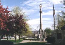
At the corner of East Main and Sussex Streets you will make a left turn down Sussex, and come to Veterans' Memorial Park at Orange Square. The city's first, and arguably most important, park was enhanced greatly during the Victorian Era. Orange Square was donated by the Delaware and Hudson Canal Company to the city in the early decades of the 19th century. It was named to honor the county, and was located in the center of the bustling canal village, though the center of town would ultimately move to the area near Jersey Avenue and Front Street. The square was designed with a series of paths emanating from a central circle where a fountain was located, a pattern retained in the current design. An impressive, multi-tiered fountain, located in the center of the park, was later moved to a location nearer to Sussex Street.
This is hallowed ground in the city. The monuments in this park represent the sacrifice our region has made in performing its duty in all of this nation's wars since the Civil War.
At the center of Orange Square today is a monument dedicated on July 5, 1886, in the presence of some ten thousand people, to the veterans of the Civil War. It was donated by Diana Farnum, who left $8,000 for its construction in her will; her two sons provided an additional $2,000. The three-mile-long dedication parade had eight hundred and fifty participants who marched to the square for the ceremony. The local newspaper called it the "greatest day that Port Jervis ever had."
The monument is forty-five feet high and fourteen feet square at ground level. At the base of the monument are four representations of the branches of military service at the time: the Infantry, Cavalry, Artillery and Navy. The soldier at its top is seven feet tall and weighs one and a half tons. The entire monument stands on a bed of bluestone and masonry that is ten feet deep.
The architect was E.F. Carr, of the firm of Frederick and Field, and when dedicated, it was considered to be one of the finest and largest monuments in southeastern New York. Contemporary accounts describe it as one of the most beautiful and finely finished monuments the firm ever designed.
In 1974, a major restoration was undertaken to repair and clean the monument after it had been exposed to railroad soot and the perils of the environment for almost a century. The cannon, placed on the square in the early years of the 20th century, dates from the Civil War. There are also monuments dedicated to honor the memory of those who served and were killed in World War I, World War II, the Korean War, the Vietnam War, and the War on Terrorism.
The park has a special place in American literary history. It was at the base of the Civil War monument where noted author Stephen Crane interviewed local veterans of the famed Civil War unit, the New York 124th Regiment, also known as the Orange Blossoms. From those interviews, and a number of other sources came one of the greatest military novels of the 19th century, The Red Badge of Courage, published in 1895. It was the first realistic portrayal of war by an American author, and accurately described the 124th's role at the Battle of Chancellorsville, Virginia in 1863. It was recently ranked as one of the most important books written in the 19th century.

Stephen Crane was born in Newark, New Jersey in 1871, the son of a Methodist minister. Before he reached twenty-five, Crane had made his mark on the American literary scene by writing two major works: Maggie: A Girl of the Streets (1893) and The Red Badge of Courage (1895). He failed a theme-writing course in college at the same time he was writing articles for newspapers, among them the New York Herald Tribune. Maggie, drawn from firsthand observations in the slums of New York, was praised and condemned for its sordid realism. By contrast, The Red Badge of Courage, also praised for its realism, was drawn entirely from newspaper accounts and research, as Crane himself never went to war.
Crane believed that the artist must live what he creates, and this adventurous spirit drove him to Cuba in 1896, providing the experience for his most famous short story, "The Open Boat," a tale of sufferings endured by Crane and his three companions aboard a lifeboat after their ship sank. He traveled to Greece as a correspondent, and returned to Cuba to cover the Spanish-American War. At the age of twenty-eight, in failing health, he traveled from England to Germany to recuperate in the healing atmosphere of the Black Forest. While working on a humorous novel, The O'Ruddy, he died in Germany of tuberculosis in June of 1900.
By Alfred S. Vedro
Stephen Crane was William H. Crane's youngest brother and a frequent visitor to his house at 19 East Main Street in Port Jervis after he left Syracuse University during the summer of 1891. The home, which you will pass, is now the offices of the law firm of Bavoso and Plotsky. In a large wicker chair on his brother Will's front porch, almost screened from view by a syringa bush, Crane created some of America's greatest literature. His camping trips throughout the region and observations of local residents also stimulated his writing and found their way into his "Sullivan County Sketches," "Whilholmville Stories" and, some believe, in his novel The Monster. He also authored occasional articles for the local newspaper, the Evening Gazette, in Port Jervis.
Crane spent more time in the Port Jervis area than anywhere else and considered it his home. At first, the Port Jervis Free Library purchased his books and local newspapers wrote proudly of him. His lifestyle, however, was unconventional, and he was later the subject of gossip that is still murmured by local residents.
Crane tried to enlist in the Army at the outbreak of the Spanish-American War; however, his tuberculosis was discovered, and kept him from service. He became a correspondent instead, and covered the battles. His courage won him the respect of soldiers, and he was commended for his bravery in dispatches. Stephen Crane is buried in the family plot in Hillsdale, New Jersey. William, who had served as his brother's legal counsel, and was a regular source of loans and lodging for him during his lifetime, was the executor of his estate. After Stephen's death, William sold the copyright to his brother's published and unpublished manuscripts to Alfred Knopf for $5,000.

138 Pike Street, Port Jervis, New York
While standing in the park, look down Pike Street and you will see the Port Jervis Free Library. While not on this walking tour, it is one of the most important legacies of the Gilded Age in Port Jervis. There has been a library in Port Jervis since 1835, when state legislation allowed for the creation of school district libraries. Efforts to enhance the library began in 1848 along with the creation of the Port Jervis Literary Association in 1865, whose main purpose was to provide for a public library and reading room.
As a result of this long-standing interest in a public library, Port Jervis became home to a Carnegie Library, the only one in Orange County and the surrounding five-county region. Now known as the Port Jervis Free Library, it was organized in August 1892, the first in New York State under the Free Library Law of 1892. Until 1903 the library was located on the second floor of the Farnum Building on lower Pike Street. By 1893 the library had outgrown its space and in 1899 efforts were begun by prominent businessmen to construct a library building in the village. Early on it became apparent it would be too expensive to erect such a building with local funds only.
After a long and dedicated effort, library advocates convinced steel magnate Andrew Carnegie to donate funds towards its construction. With a contribution of land made by local businessman Peter Farnum, and a substantial donation of $30,000 by Carnegie, the building of a library became possible. In February 1901, local residents were, according to the local newspapers, "electrified" by the announcement of Carnegie and Farnum's donations.
The library was designed by W. S. Ackerman of the New York City architectural firm of Ackerman and Ross, and was built by local contractor Lorenzo Wood. The cornerstone was laid in 1902, and opening ceremonies took place in 1903. The firm had also designed Carnegie libraries for Washington, D.C.; Atlanta, Georgia; San Diego, California; East Orange, New Jersey and Utica, New York.
It was dedicated during the height of one of America's greatest and most famous philanthropies which ultimately amounted to forty million dollars. It is one of 1,679 libraries given to 1,412 towns and cities across America. Today it is one of only a few hundred Carnegie libraries that survive and are still used for their original purpose or some other municipal function. Carnegie, known as the "Patron Saint of Libraries," is supposed to have said that "The Library building is built to last." And, indeed it has.
The library was the first in Orange County to have a separate children's reading room and it was annually a leader in the state in acquiring new books, ranking in the top thirty per cent. It was the first library in the state to establish a permanent maintenance fund, a condition for the Carnegie donation. By 1903 there were 14,000 books in the collection, with 1,000 books being added annually. A contemporary library report concludes that the "volumes of the best thought of the brightest minds of the world, ever ready to talk to us in the best of language" were available for loan, and that mission remains to this day.
The library has a complete collection of the works of Stephen Crane and an excellent collection of materials related to him. This building is also home to the Minisink Valley Historical Society, which has an important local history archive including photographs, books, pamphlets, and files and materials related to Stephen Crane.
Onwood Lake, West Main Street, Port Jervis, New York
Abandoned Canal
The Delaware and Hudson Canal
As you continue along Broome Street you will make a right turn onto Canal Street, which follows the route of the Delaware and Hudson Canal within the city limits. The long and colorful history and financial success of the Delaware and Hudson Canal, which ran 108 miles from Honesdale, Pennsylvania, to Kingston, New York, is one of the great success stories of the 19th century. That success can be attributed to the dedication and service of the management, stockholders, engineers, supervisors, boatmen, locktenders and laborers. Some of these men and women spent their entire working lives employed on the canal. At its greatest moment, in the mid-19th century, hundreds of boats were on the canal at any given time, each carrying 140 tons of coal.
The Delaware and Hudson Canal Company holds a special place in American corporate history as the country's first corporation capitalized at one million dollars. It was a great developer of new technology, not unlike the space program of the 20th century. Its total operations may have been the first vertically integrated company in the nation, long before the rise of the colossus Standard Oil.
Before canal construction began, the areas it would traverse, particularly along the Delaware and Lackawaxen rivers, were a virtual wilderness with few inhabitants. Many small communities, now nearly forgotten, were created by, and thrived because of the canal. Substantial population growth, communication, and commercial development occurred as a result of the availability of transportation, a new energy source, and the flow of products to new markets along the route of the canal. Places like Honesdale, Port Jervis, Wurtsboro and Bolton were named after company officials, and in some cases the company's engineers laid out plans for towns through which the canal would pass.
Today the canal is just a memory, and the famed D & H Railroad Company, successor to the canal company, declared bankruptcy and is now part of the Canadian Pacific railroad system. It is a far cry from when the D & H was one of the country's great transportation institutions. At West Main Street you will make a left turn and cross over the former canal basin and boatyard. To your right is the location of the former canal hotel, and across Main Street, on your right, is a building that was also a canal-era structure.
Another city-owned trail is the D & H Canal Heritage Trail which begins at the juncture of Grandview Avenue and West Main Street. It is about two and a half miles long and follows the old canal towpath that was used by mules pulling the large boats. Copies of that trail guide can be obtained by writing the Minisink Valley Historical Society.
Point Peter and Mount William
As you proceed along West Main Street you pass beneath Point Peter and Mount William. They are on the edge of the large Appalachian Plateau that extends across the southern tier of New York State. Above, on the plateau, is the city-owned Elks-Brox Memorial Park with picnic areas, bathrooms and trails. It was during the Gilded Age, from 1880-1920, that the entire nation began to yearn for open spaces that were fast disappearing as the West was being settled. Noted Wisconsin historian Frederick Jackson Turner lamented the closing of the nation's last frontiers. It was during this time that the National Park System and United States Forest Reserves were being created by the U.S. Congress. In New York State, the Catskill and Adirondack preserves were being formed.
Port Jervis has long associated itself with the Catskill and Shawangunk mountains. Its proximity to the forested wild areas was cause for great self-promotion. In one brochure, it was called the "Scenic Queen of the Shawangunk Range."
It was during the Gilded Age that the largest park in the city was developed, the Elks-Brox Memorial Park, located on what was then called the Twin Mountain Tract. As early as 1911, local citizens became concerned with the future of the property that overlooked the city and had an impressive view of the Shawangunk and Kittatinny mountains, along with the Delaware and Neversink river valleys. At that time the former owner, Almira St. John Mills, had just died, and the property was about to be disposed of by her estate.
Port Jervis residents turned down a proposal to buy it, by a vote of 191-123, but immediately after the vote, Port Jervis Lodge No. 645 of the Benevolent and Protective Order of Elks began discussions to purchase the property. In 1914 the Elks, seeing the possibilities of the development of the area as a public park, raised the necessary funds to purchase the tract under the leadership of the Rev. William J. Donohue, then pastor of the Most Sacred Heart Church. The property was named Elks Park.
In the years that followed, Skyline Drive, a four-mile road that ran along the crest of the two mountains, was built, and other improvements to the park were made. In 1932, Sarah Belle Thorne made a substantial donation in memory of her brother-in-law, Charles Brox, and the property was conveyed from the Elks to the city and became known as the Elks-Brox Memorial Park. In later years, part of it was used as a Girl Scout Camp, and as late as the 1980s, a public campground. In 1996 the park's facilities were upgraded and new picnic areas, trails, and bathrooms were constructed
As you proceed along West Main Street you will cross the West End Bridge. As you look to your right you will see what is left of the Delaware Division's large freight yards that at one time contained seventy-five miles of track. To your left you will see what remains of the shops, engine facility and yards where at one time twenty-five hundred men worked twenty-four hours a day in a roundhouse with a turntable, and the car repair shops. Today about twenty men work on the railroad here. With the departure of the Erie Railroad's shops in the 1950s and 1960s, Port Jervis entered a long period of economic decline.
Also, on the horizon to your left is the High Point monument, dedicated to honor the veterans of New Jersey, and located at the highest point in the state of New Jersey at 1,803 feet above sea level. The monument is an additional two hundred and twenty feet tall, and from its peak can be seen a panoramic view of the Tri-State Region. The ridges to the right of the monument are the Kittatinny or Blue Mountains, and to the left are the Shawangunk Mountains, or "Gunks" as they are known locally. The monument is located in a 15,000-acre state park owned by New Jersey.
At the bottom of the hill you will return to Fort Decker. Please cross the street carefully as the traffic is heavy here. Thank you for visiting our city, and we hope your time here was enjoyable.
One of the unique places not on the Delaware River Heritage Trail but worth visiting is Gillinder Glass, located at the corners of Erie and Liberty Streets in Port Jervis, just a few blocks from Fort Decker. As one of the oldest glass companies in the United States, Gillinder Glass is a name well-known. One can still visit the factory and see Gillinder glass being created. The time-honored techniques used to handcraft each piece of glass today are the same as those used by the company for more than a century. Feel the excitement on the factory floor and the heat from the large furnaces as you watch molten glass being handled and transformed into beautiful, useful and decorative glass objects.
As you browse through the glass museum in the turn of the 20th century plant you will learn about the history of local glass making as well as Gillinder Glass' proud heritage. The factory store includes many glass items produced from the original designs and molds in the Gillinder archives as well as some new favorites. To find out more information about the museum and when it is open call 845-856-5375.
The Port Jervis Fire Department maintains a display of fire memorabilia in its 19th century restored fire station on Orange Street. The displays include artifacts from times past including 19th century firefighting equipment. To find out more information about the museum and when it is open call 845-858-4017.
The following resources are available for further exploration of the Delaware River and its history:
- Canoeing the Delaware River: A Guide to the River and Shore by Gary Letcher
- Delaware Diary and Bridges of the Delaware by Frank Dale
- Down the Delaware: A River User's Guide by Charlotte McCabe
- Natural Lives, Modern Times: People and Places of the Delaware River by Bruce Stutz
- Postcards of America: Along the Delaware River by Richard C. Albert and Carrie E. Albert
- Two Hundred Miles on the Delaware River by J. Wallace Hoff
- White Water Boating on the Upper Delaware River by Aaron Robinson
The following resources are available for further exploration of the area's history:
- Images of America: Deerpark by Brian Lewis
- Images of America: Dingmans Ferry by Matt Osterberg
- Images of America: High Point State Park & the Civilian Conservation Corps by Peter Osborne
- Images of America: Matamoras to Shohola by Matt Osterberg
- Images of America: Port Jervis by Matt Osterberg
- Images of America: The Delaware and Hudson Canal and Gravity Railroad by Matt Osterberg
A full bibliography on the area's history can be found on the Minisink Valley Historical Society's web page at http://www.minisink.org.
The design and construction of the trail is a result of the efforts of many organizations, agencies and individuals including the Minisink Valley Historical Society, the City of Port Jervis, the city's Department of Public Works, the Tri-State Chamber of Commerce, Gillinder Glass, the Port Jervis Tourism Board, the former Orange County Delaware River Festival Committee, the Port Jervis Recreation Commission, Laurel Grove Cemetery Association, the Council on Disabilities, Orange and Rockland Utilities, Lynne Wallace, Robert Eurich, William Clark, Doug Delorie, Jeanne Moore, Mike Falcone, Steve Padgett, New York State Thruway, former Port Jervis mayors Michael Worden and Ross Decker, current mayor Gary Lopriore and Adam Hubbard. Tom Burrows, of Action Toward Independence, designed the new ADA compliant sections of the trail.
The original trail was built in 1993; a Community Investment Grant in 1996 from Orange and Rockland Utilities allowed the Minisink Valley Historical Society to double its length, improve the markings and enhance the route to include all of the city's most important historic sites.
In 2006, the City of Port Jervis received a grant from New York through the offices of New York State Senator John Bonacic to upgrade the trail, create this brochure, install ADA compliant facilities and design new directional signage. Sean Addy and addyart.com designed the trail's handsome logo and Rick Hibbard designed the guide's cover and provided technical assistance in designing the booklet. This booklet has been written by Peter Osborne, with assistance from Nancy Conod, Barbara Johnson, Janis Osborne, Nancy Vocci, and Fred Weissman.
For more information about the area's rich history and many attractions please feel free to contact the following: